Trek Route Maps
 Ek Shabda · One Word
 Amar Vani · Eternal Voice
 Boli · Voices of Home
 Naksha · Maps
Poon Hill trek map: every stop and altitude, Nayapul to Ghandruk

On this page
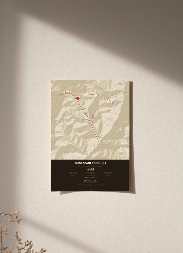
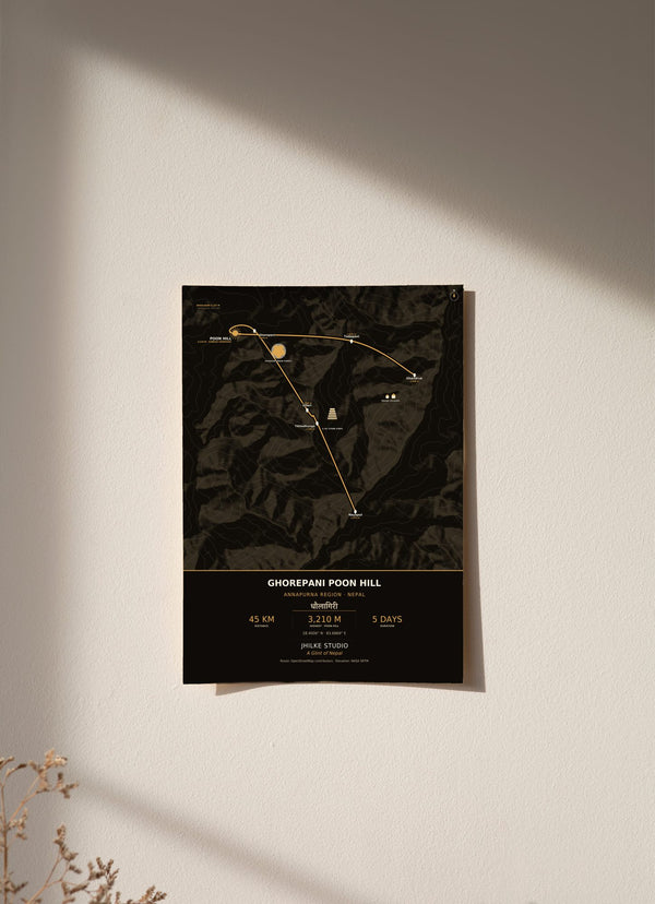
The Poon Hill trek map on our print follows a horseshoe route from Nayapul at 1,070 m up to Poon Hill at 3,210 m and back down to Ghandruk: about 45 km in 5 days, through seven stops in the Annapurna region of Nepal. Below is each stop in walking order with its altitude, where the big climbs are, and what the print does and does not show.
What are the stops on the Poon Hill trek map?
There are seven stops, in walking order: Nayapul, Tikhedhunga, Ulleri, Ghorepani, Poon Hill, Tadapani and Ghandruk. The route starts at Nayapul (1,070 m), climbs to Poon Hill at 3,210 m, the highest point on the map, then descends through Tadapani (2,630 m) to Ghandruk (1,940 m), the last stop.
- Nayapul, 1,070 m: the start.
- Tikhedhunga, 1,540 m: up 470 m.
- Ulleri, 1,960 m: up 420 m.
- Ghorepani, 2,870 m: up 910 m, the biggest single climb on the route.
- Poon Hill, 3,210 m: up 340 m, the highest point.
- Tadapani, 2,630 m: 580 m lower than Poon Hill.
- Ghandruk, 1,940 m: 690 m lower than Tadapani, the end of the line.
How long is the Poon Hill trek?
Our map gives the trek as about 45 km in 5 days. From Nayapul to Poon Hill the printed altitudes rise by 2,140 m, and the route then loses 1,270 m on the way down to Ghandruk. Treat these figures as the outline printed on the map, not as an itinerary.
The climb is not even. The first two stops add 470 m and 420 m. The step from Ulleri up to Ghorepani is the largest on the map, at 910 m. After that, Poon Hill adds a further 340 m.
What is the Poon Hill trek route?
The route is a horseshoe. It climbs through rhododendron forest and the stone staircase between Tikhedhunga and Ulleri to Ghorepani, makes a dawn side trip to the Poon Hill viewpoint, then comes down through Tadapani to Ghandruk, a Gurung and Magar village.
The print notes 3,767 stone steps on that staircase, which gains 420 m between Tikhedhunga (1,540 m) and Ulleri (1,960 m). Poon Hill is the dawn side trip from Ghorepani, and it is where the view is the point. For that reason the map marks it with a sun glint icon rather than a peak triangle.
Where is Poon Hill, and what can you see from it?
Poon Hill is in the Annapurna region of Nepal, at 3,210 m, at the coordinates 28.4006° N, 83.6869° E, which are printed on the map. From the viewpoint at sunrise you see Dhaulagiri (8,167 m) and the Annapurna range.
Dhaulagiri is marked off the edge of the map on its compass bearing, with the caption "seen at sunrise, 38 km NW". Its name is printed in Devanagari as धौलागिरी.

Is there a Poon Hill trail map PDF?
We do not sell a PDF. Our Poon Hill trek map is a printed wall map with seven stops and their altitudes, and it is not made for navigation. On the trail, carry a proper trekking map or an offline map app.
The stop positions on our print come from OpenStreetMap, and the terrain comes from NASA SRTM elevation data. The footer of the map credits both. (Sources: © OpenStreetMap contributors; NASA SRTM.)
What is on the Poon Hill trek map poster?
The poster is a full-bleed map built from real elevation data. The terrain is from NASA SRTM, with contour lines every 300 m, and each stop is marked with its altitude beside it. The route runs as one line from Nayapul, over Poon Hill, and down to Ghandruk.
The dark version has a near black base with a gold route line. The light version has a warm cream base, a deep terracotta route line and dark ink labels. Both come in 30 x 40, 50 x 70 and 70 x 100 cm, as an unframed fine art print, wood framed or acrylic glass. An unframed 30 x 40 cm print costs €29.95.
If Poon Hill is part of your story, the map is here in light and dark. The other routes are in the Trek Route Maps collection, and the Annapurna Base Camp map guide covers the longer trek that shares Nayapul and Ghandruk with this one.
Questions
Can I use this Poon Hill trek map for navigation?
No. It is a decorative wall print showing seven stops and their altitudes. Use a trekking map or an offline map app on the trail.
How high is Poon Hill?
3,210 m, the highest point on our map. The trek starts at Nayapul, 1,070 m.
Why is Poon Hill marked with a sun and not a peak?
Because the view is the point of Poon Hill. The map uses a sun glint icon for the viewpoint, where you watch sunrise over Dhaulagiri and the Annapurna range.
Does this map cover the Annapurna Base Camp trek or the Mardi Himal trek?
No. This print covers the Ghorepani Poon Hill horseshoe only. It shares Nayapul (1,070 m) and Ghandruk (1,940 m) with the Annapurna Base Camp route, which has its own map.
Where does the Poon Hill trek on the map end?
At Ghandruk, 1,940 m, a Gurung and Magar village, after the descent from Poon Hill (3,210 m) through Tadapani (2,630 m).
How much does the Poon Hill trek map print cost?
From €29.95 for an unframed 30 x 40 cm print. Delivery within the EU is €5.95, free from €40.