Trek Route Maps
 Ek Shabda · One Word
 Amar Vani · Eternal Voice
 Boli · Voices of Home
 Naksha · Maps
Upper Mustang trek map: every stop and altitude, Jomsom to Lo Manthang

On this page
- What are the stops on the Upper Mustang trek map?
- Is there an Upper Mustang trek map with distance?
- What does the Upper Mustang trek map show?
- Where is Upper Mustang on the map of Nepal?
- Does the Upper Mustang print have a Devanagari word on it?
- Is there an Upper Mustang trek map PDF?
- What is on the Upper Mustang trek map poster?
- Questions
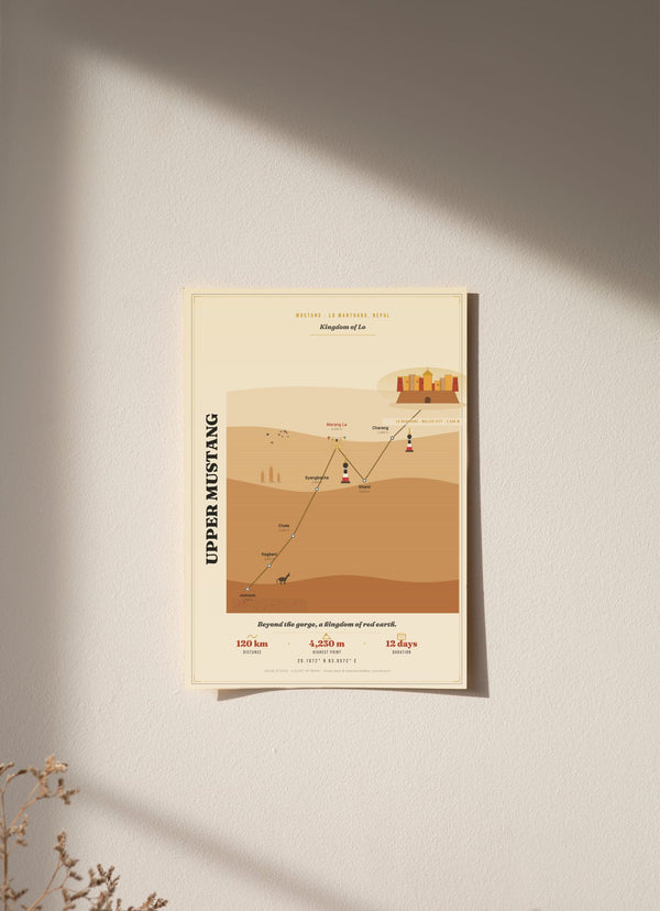
The Upper Mustang trek map on our print follows the trail from Jomsom at 2,720 m to Lo Manthang at 3,840 m, the walled capital of the once-forbidden Kingdom of Lo. The print states 120 km and 12 days, and its highest point is the pass Marang La at 4,230 m. Below is each of the eight stops in walking order with its altitude. One thing to know first: the print is an illustration, and it does not show the trail seen from above.
What are the stops on the Upper Mustang trek map?
The print has eight stops, in walking order: Jomsom, Kagbeni, Chele, Syangboche, Marang La, Ghami, Charang and Lo Manthang. The route starts at Jomsom at 2,720 m, climbs to Marang La at 4,230 m, the highest point on the print, then drops to Ghami at 3,520 m before the last climb to Lo Manthang at 3,840 m.
- Jomsom, 2,720 m: the start.
- Kagbeni, 2,810 m: up 90 m.
- Chele, 3,050 m: up 240 m.
- Syangboche, 3,800 m: up 750 m, the biggest single climb on the print.
- Marang La, 4,230 m: up 430 m. This is the pass and the highest point.
- Ghami, 3,520 m: down 710 m.
- Charang, 3,560 m: up 40 m.
- Lo Manthang, 3,840 m: up 280 m, the end of the route.
Is there an Upper Mustang trek map with distance?
Our print gives one distance, the total: 120 km and 12 days, as printed. It gives an altitude for each stop, not a distance between stops, so this page quotes none. The climb is easier to follow in height. Jomsom to Marang La is a gain of 1,510 m, and Jomsom to Lo Manthang is a net gain of 1,120 m.
Five of the eight stops sit above 3,500 m: Syangboche, Marang La, Ghami, Charang and Lo Manthang. Only Marang La is above 4,000 m.
What does the Upper Mustang trek map show?
The Upper Mustang trek map print is an original illustration of the route through its eight stops, over layered canyon ridges. Its centre is a plan of the walled city of Lo Manthang: the rampart, four corner bastions, the gate and a gompa roof. Along the trail it carries painted chortens, sky caves, a horse, and apple and barley fields.
Mustang chortens are painted in bands of red, white, black and grey. The print also gives the coordinates of Lo Manthang, 29.1872° N, 83.9572° E.

Where is Upper Mustang on the map of Nepal?
Upper Mustang is in the Mustang region of Nepal. The trail follows the high desert gorge of the Kali Gandaki north from Jomsom to Lo Manthang, the walled capital of the once-forbidden Kingdom of Lo. The coordinates printed on the poster, 29.1872° N, 83.9572° E, point to Lo Manthang.
Does the Upper Mustang print have a Devanagari word on it?
The Upper Mustang print has no Devanagari word. Most of our other trek prints carry a word in Devanagari, the script used for Nepali and Sanskrit. This one has none on purpose. Lo Manthang and Mustang are Tibetic names, not Sanskrit-derived Nepali words, so a Devanagari spelling would misstate the language of the region.
Is there an Upper Mustang trek map PDF?
We do not sell a PDF. Our Upper Mustang trek map is a printed wall poster with eight stops and their altitudes, and it is not made for navigation. On the trail, carry a proper trekking map or an offline map app. The route data on the print is © OpenStreetMap contributors, and the stop heights are published heights. (Source: © OpenStreetMap contributors.)
What is on the Upper Mustang trek map poster?
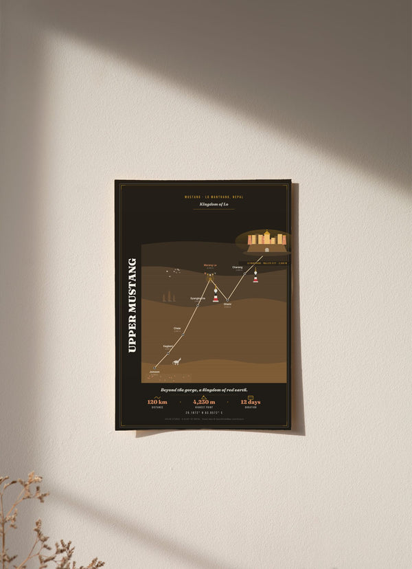
The poster carries the eight stops with their altitudes, the plan of Lo Manthang, the canyon ridges, the chortens and the horse. It comes in a light version (tan and cream) and a dark one (deep ink with parchment text), each in 30 x 40, 50 x 70 and 70 x 100 cm. An unframed 30 x 40 cm print costs €29.95.
The print is here in light and dark, each as an unframed fine art print, wood framed or acrylic glass. The other trek routes are in the Trek Route Maps collection. For a print that charts one long climb as an elevation profile, see the Manaslu Circuit trek map.
Questions
Is the Upper Mustang trek map a plan view map?
The Upper Mustang trek map is an original illustration of eight stops with their altitudes over canyon ridges, with a plan of the walled city of Lo Manthang at its centre. It does not show the trail seen from above.
Can I use this Upper Mustang trek map for navigation?
This Upper Mustang trek map is a decorative wall print, so it is not for navigation. Use a trekking map or an offline map app on the trail.
How high is Marang La?
Our print gives Marang La as 4,230 m, the highest point on the route. It sits between Syangboche at 3,800 m and Ghami at 3,520 m.
Which stops on the Upper Mustang trek map are above 3,500 m?
Syangboche (3,800 m), Marang La (4,230 m), Ghami (3,520 m), Charang (3,560 m) and Lo Manthang (3,840 m).
How much does the Upper Mustang trek map print cost?
From €29.95 for an unframed 30 x 40 cm print, in the light or the dark version. Larger sizes and framed or acrylic glass prints cost more, and each price is shown on the product page.