Trek Route Maps
 Ek Shabda · One Word
 Amar Vani · Eternal Voice
 Boli · Voices of Home
 Naksha · Maps
Manaslu Circuit trek map: every stop and altitude, Soti Khola to Bimthang

On this page
- What are the stops on the Manaslu Circuit trek map?
- Is there a Manaslu Circuit trek map with distance?
- What does the Manaslu Circuit elevation map show?
- Where is the Manaslu Circuit on the map of Nepal?
- Is there a Manaslu Circuit trek map PDF?
- Is the Manaslu print a map?
- What is on the Manaslu Circuit trek map poster?
- Questions
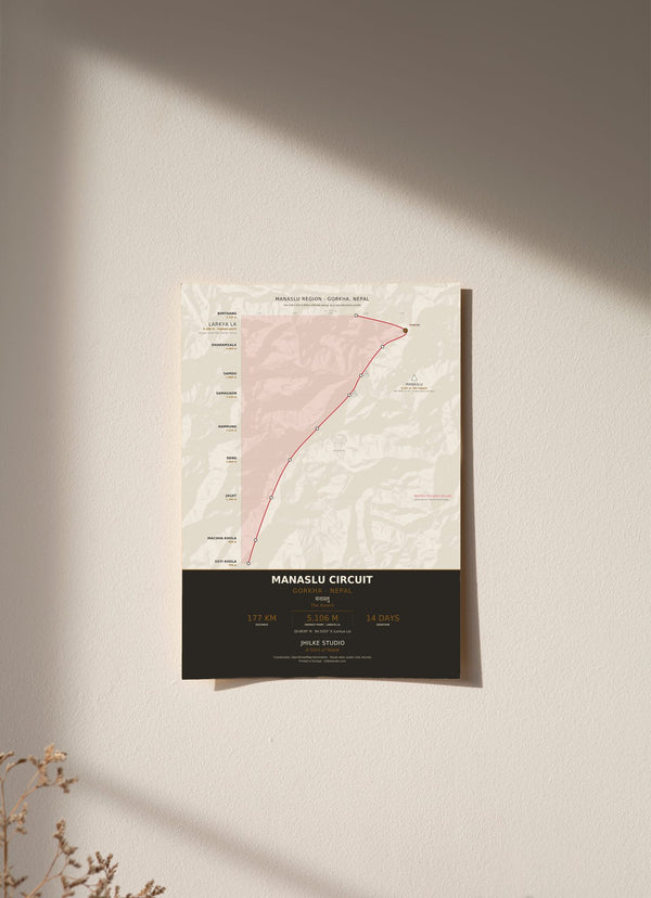
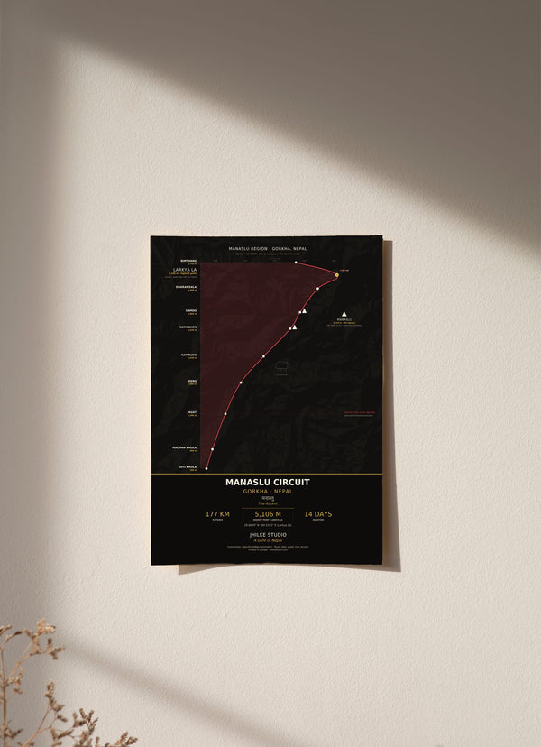
The Manaslu Circuit trek map on our print, called The Ascent, follows the trek from Soti Khola at 700 m up to Larkya La at 5,106 m and down to Bimthang at 3,720 m: about 177 km in 14 days, through ten stops in the Manaslu region of Gorkha, Nepal. One thing to know first: the print is an elevation profile chart. It does not show the trail seen from above. Below is each stop in walking order with its altitude, and what the chart does and does not show.
What are the stops on the Manaslu Circuit trek map?
There are ten stops, in walking order: Soti Khola, Machha Khola, Jagat, Deng, Namrung, Samagaon, Samdo, Dharamsala, Larkya La and Bimthang. The route starts at Soti Khola (700 m), climbs to Larkya La at 5,106 m, the highest point on the print, then drops to Bimthang at 3,720 m.
- Soti Khola, 700 m: the start, in the Budhi Gandaki gorge.
- Machha Khola, 900 m: up 200 m.
- Jagat, 1,340 m: up 440 m. The print marks the permit requirement here.
- Deng, 1,860 m: up 520 m.
- Namrung, 2,630 m: up 770 m.
- Samagaon, 3,530 m: up 900 m, the biggest single gain on the route.
- Samdo, 3,860 m: up 330 m.
- Dharamsala, 4,460 m: up 600 m. Some call it Larke Phedi.
- Larkya La, 5,106 m: up 646 m, the pass beneath Manaslu.
- Bimthang, 3,720 m: down 1,386 m on the far side of the pass.
Is there a Manaslu Circuit trek map with distance?
Our print gives the trek as about 177 km in 14 days, which is the published trail total. The chart also has a distance axis, but it uses straight line distances between stops, and those are shorter than the walked trail. For that reason we do not quote a distance for any single stop.
The climb is easier to read in vertical metres. From Soti Khola up to Larkya La the route gains 4,406 m. Five of the ten stops sit above 3,000 m: Samagaon, Samdo, Dharamsala, Larkya La and Bimthang. Only two are above 4,000 m, Dharamsala and Larkya La. The gains grow through the lower valley, from 200 m to Machha Khola to 900 m between Namrung and Samagaon, then ease to 330 m into Samdo before the push to the pass.
What does the Manaslu Circuit elevation map show?
The Manaslu Circuit elevation map is a vertical elevation profile chart, read from the base of the page to the summit. Each stop's altitude and the trail's cumulative distance are drawn as the trek's cross section, over a background hillshade made from SRTM elevation data. Stop coordinates are geocoded from OpenStreetMap.
Manaslu itself, at 8,163 m the 8th highest mountain on Earth, is placed on the print at its bearing and distance from Samagaon: 244.9 degrees, west southwest, 9.1 km. Around the route the chart carries yak pastures, prayer flags at the pass and Manaslu's summit. It prints the coordinates of Larkya La, 28.6639° N, 84.5203° E, and the name of the mountain in Devanagari, मनास्लु.
Where is the Manaslu Circuit on the map of Nepal?
The Manaslu Circuit is in the Manaslu region of Gorkha, Nepal. The walk starts at Soti Khola, 700 m, in the Budhi Gandaki gorge and crosses Larkya La, the pass beneath Manaslu. Samagaon and Samdo, at 3,530 m and 3,860 m, are Tibetan chorten villages beneath the mountain.
The region has been a restricted area since it opened to trekkers in 1991. A Restricted Area Permit is required for the stretch between Jagat and Samagaon, and the print marks this at Jagat. The height of Larkya La is cited from 5,106 m to 5,160 m depending on the source. Our print uses 5,106 m, the most commonly cited figure.

Is there a Manaslu Circuit trek map PDF?
We do not sell a PDF. Our Manaslu Circuit trek map is a printed wall chart that shows ten stops and their altitudes, and it is not made for navigation. On the trail, carry a proper trekking map or an offline map app.
The stop coordinates behind our print come from OpenStreetMap. (Source: © OpenStreetMap contributors.)
Is the Manaslu print a map?
The Manaslu print is an elevation profile chart, not a map seen from above. A plan view map shows the trail from above, with the valleys and ridges laid out flat. The Manaslu print shows the trek as a cross section, so you read the climb to Larkya La as height up the page rather than as a path across it.
That choice suits this trek, where the story is the altitude. The print runs from the 700 m gorge at Soti Khola to the pass at 5,106 m, with each stop marked and its altitude printed beside it.
What is on the Manaslu Circuit trek map poster?
The poster carries the ten stops, the altitude of each, the hillshade behind them, Manaslu placed at its bearing from Samagaon, and the yak pastures and prayer flags along the way. It comes in a light version and a dark version.
Both come in 30 x 40, 50 x 70 and 70 x 100 cm, as an unframed fine art print, wood framed or acrylic glass. An unframed 30 x 40 cm print costs €29.95.
If the Manaslu Circuit is part of your story, the print is here in light and dark. The other trek routes are in the Trek Route Maps collection, and the Annapurna Circuit map guide covers the other big circuit in the same way.
Questions
Is the Manaslu Circuit trek map a plan view map?
No. It is an elevation profile chart that shows each stop's altitude and the trail's cumulative distance as a cross section, over a hillshade.
Can I use this Manaslu Circuit trek map for navigation?
No. It is a decorative wall print showing ten stops and their altitudes. Use a trekking map or an offline map app on the trail.
How high is Larkya La?
Our print uses 5,106 m, the most commonly cited figure. Sources cite it anywhere from 5,106 m to 5,160 m. It is the highest point on the map.
Which stops on the Manaslu Circuit are above 4,000 m?
Dharamsala (4,460 m), also called Larke Phedi, and Larkya La (5,106 m).
Is the Manaslu region a restricted area?
Yes, it has been restricted since it opened to trekkers in 1991. A Restricted Area Permit is required for the stretch between Jagat and Samagaon, and our print marks this at Jagat.
How much does the Manaslu Circuit trek map print cost?
From €29.95 for an unframed 30 x 40 cm print. Delivery within the EU is €5.95, free from €40.