Trek Route Maps
 Ek Shabda · One Word
 Amar Vani · Eternal Voice
 Boli · Voices of Home
 Naksha · Maps
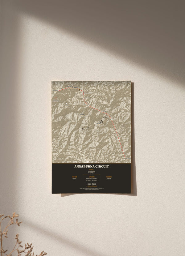
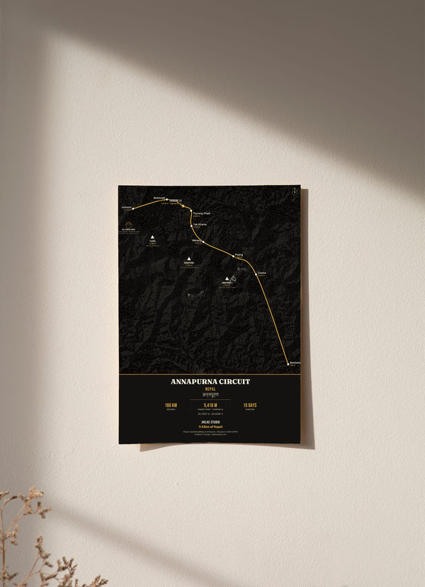
Annapurna Circuit map: every stop and altitude, Besisahar to Jomsom

On this page
The route on our Annapurna Circuit map covers about 160 km in roughly 15 days, from Besisahar at 760 m over Thorong La at 5,416 m, the highest point of the trek, and down to Jomsom at 2,720 m. Below is the route the way our map draws it: nine stops, in the order you walk them, with the altitude of each.
What are the stops on the Annapurna Circuit map?
- Besisahar, 760 m: the start.
- Chame, 2,670 m: up 1,910 m.
- Pisang, 3,300 m: up 630 m.
- Manang, 3,540 m: up 240 m.
- Yak Kharka, 4,050 m: up 510 m.
- Thorong Phedi, 4,540 m: up 490 m.
- Thorong La (pass), 5,416 m: up 876 m.
- Muktinath, 3,760 m: down 1,656 m.
- Jomsom, 2,720 m: down 1,040 m.
Distance about 160 km. Highest point 5,416 m at Thorong La. About 15 days. Thorong La sits at 28.7935° N, 83.9389° E.
How does the altitude build?
The first leg does most of the climbing in one sweep: from Besisahar at 760 m to Chame at 2,670 m, nearly 2,000 m higher. After that the gains get smaller and slower. Pisang, Manang, Yak Kharka and Thorong Phedi each sit a few hundred metres above the last.
The middle section stays at high altitude. Yak Kharka, Thorong Phedi and Thorong La are above 4,000 m, and Thorong Phedi, the last stop before the pass, is at 4,540 m.
What is the hardest day on this route?
On paper it is one line on the map. In numbers it is the biggest day of the circuit:
- up 876 m, from Thorong Phedi (4,540 m) to Thorong La (5,416 m)
- then down 1,656 m, from the pass to Muktinath (3,760 m)
That is about 2,500 m of climbing and descending in a single day. The last leg, Muktinath to Jomsom, drops another 1,040 m.
What do you see along the route?
Three big peaks rise around the route: Annapurna II (7,937 m), Gangapurna (7,455 m) and Tilicho (7,134 m). The final stretch follows the Kali Gandaki, often called the world's deepest gorge, near Kagbeni. Its riverbed is known for Shaligram stones, which are revered as a form of Vishnu.


How is our Annapurna Circuit map drawn?
The route is drawn as a single line with each stop marked in walking order and its altitude printed beside it. The terrain comes from real elevation data, and the route data from OpenStreetMap. (Source: © OpenStreetMap contributors.) The name अन्नपूर्ण (Annapurna) appears in Devanagari at the top. It comes in a light version (cream, warm terrain, terracotta route) and a dark one (near-black terrain, gold route).
If the circuit is part of your story, the map is here: Annapurna Circuit map, light and dark.
Browse the Trek Route Maps collection. For another part of Nepali life, read five Nepali proverbs and their meanings.
Questions
Can I use this Annapurna Circuit map for navigation?
It is a decorative wall print showing nine waypoints and their altitudes. It is not a trail navigation map.
How long is the Annapurna Circuit?
About 160 km, walked in roughly 15 days on the route shown here.
How high is Thorong La?
5,416 m, at Thorong La.
Where does it start and finish?
This version starts in Besisahar (760 m) and finishes in Jomsom (2,720 m).
Which stops are above 4,000 m?
Yak Kharka (4,050 m), Thorong Phedi (4,540 m) and Thorong La itself (5,416 m).
What is the hardest day?
By the numbers, the pass day: 876 m up from Thorong Phedi to Thorong La, then 1,656 m down to Muktinath.
The distance and duration above describe the route on our print. The Nepal Tourism Board also gives Thorong La as the trek’s high point at 5,416 m, and describes a longer route ending at Naya Pool. (Source: Nepal Tourism Board, Annapurna region.)
Written by Amrit Sharma Dahal, Jhilke Studio, Almada, Portugal. Figures are the ones printed on our Annapurna Circuit map. Last updated 30 September 2026.